University of California, Irvine
Instructor: Dr. Barbara J. Becker
|
Lecture 12. Extending Human Capabilities
|
Water Water Everywhere... Getting where you want to go without modern instruments is difficult enough on land, but travel on the high seas presents additional challenges. If your craft is powerless and rudderless, it will be subject to the whims of the wind and carried along by underlying currents. If you are in an oared vessel, you could drive it in any desired direction provided you have the strength and stamina to keep it moving. If your vessel has a sail, you could take advantage of the wind's power so long as your destination lies in the direction the wind is blowing. Unless you are happy to land wherever Nature takes you, getting from one place on the open sea to another introduces some very perplexing problems:
|
|
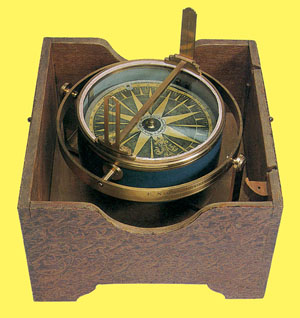
By the 15th century, navigational tools included the mariner's compass which could be used for general orientation, especially in cloudy weather. |
|
|
For long distance voyages, it was important to have someone on board the vessel who was familiar with the positions and celestial coordinates of the fixed stars on the sky. It was also essential to have an ephemeris -- a table listing the predicted positions of selected bright stars and planets (including the Sun and Moon) at designated times for each day of the year.
Using sighting instruments like the crossstaff to check the positions of celestial bodies required a great deal of training, experience and good luck.
None of these navigational tools guaranteed an error-free voyage. One degree of latitude equals roughly 69 modern terrestrial miles, but one degree of longitude varies with latitude. Positional measurements that are off by a small fraction of a degree could mean a difference in position of several miles. |
|
|
|
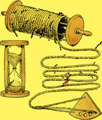
The configuration of the continents bounding the Atlantic Ocean made it hard for sailors to miss making landfall somewhere on the opposite shore if they simply maintained a constant heading and kept their vessel moving. This navigational method is called 'dead reckoning' -- short for 'deduced reckoning'. Gauging a ship's progress was a matter of keeping regular track of its speed. One early method for accomplishing this involved dropping a floating object from the ship's bow and timing how long it took to float past the stern. Before timers like sandglasses were introduced, subjective methods of measuring these intervals were employed, like counting repetitions of a short common prayer or verse. By 1590, a refinement to this method of tracking a ship's speed known as 'log and line' had been introduced. The log, or chip, was a piece of wood cut in the shape of a quarter circle that was secured to a long rope -- the line.
Log, line and timer. The line was often 150 fathoms (900 feet) long. When not in use it was kept neatly coiled around a free-rolling spindle. At its log end, a ship's length of the line would be kept knot-free. A red cloth was attached at that point to mark the beginning of a series of knots tied at regular intervals, usually every 7 or 8 fathoms (42 or 48 feet). One sailor would throw the log off the ship's stern. The reelman would hold the spindle aloft and let the line pay out. As soon as the red cloth appeared in the water, the log was deemed far enough behind the ship to be floating free of disturbance from its motion. The reelman would then shout "Turn!" to signal the timer to turn over the sandglass. When the sand had run out -- usually 28-30 seconds later -- the timer would shout "Stop!" The reelman would stop the line and then count the knots that had paid out. Heaving the log and line became a valued ritual repeated as often as once every hour. The result of each measure was dutifully written down in a book that became known as the ship's log. |
|
|
Mariners in the open ocean could readily determine their latitude by comparing their observations with star maps and tables listing changes in the sun's height above the horizon. How far east or west they had traveled from their home port was a more difficult matter. The search for a solution to the "longitude problem" led to improvements in astronomical instruments, the organization of scientific research, and in the design of timekeepers. |
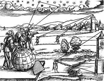
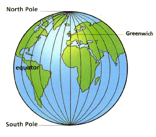
The Earth spins on a north-south axis that hardly changes its orientation from century to century. This accounts for the relative stability in the north-south orientation of the map of the fixed stars. Using familiar celestial markers as guides (the star Polaris, for example), a navigator out in the open sea can readily determine her geographic latitude (position north or south of the equator). Figuring out her longitude (position in the east-west direction) is a different story. There is nothing comparable to the equator or the poles for the navigator to use as reference points. It is inconvenient for everyone around the globe to awaken, work and sleep according to a schedule defined by a single global clock. Most people in Hong Kong, Los Angeles and Nairobi prefer to rise with the Sun, mark the noon hour when the Sun crosses the local meridian and sleep after the Sun has set. The Earth makes one complete turn on its axis nearly every twenty-four hours. As shown in the illustration above, every 15° of longitude (360° ÷ 24) marks a difference of one hour in local time. Longitude measures are intimately connected to time -- in particular, to comparisons of local time in different parts of the globe. To see how a navigator in the open sea can use time to determine her longitude, imagine that each day, when her trusty chronometer tells her it is precisely noon in London, she determines her own local time by observing the Sun's position on the sky. On the first day, when her chronometer strikes twelve noon, she notes her local time is 11 a.m., a reading that lets her know she is currently located 15° west of London. On the second day, she sees that her local time is only 10 a.m., an indication that she is now 30° west of London. Unfortunately, her chronometer falls and breaks on the third day! With no way of knowing when it is precisely noon in London, she has no signal to tell her when to measure her local time. Unable to compare her local time with time in London, she is left with no easy way to determine her longitude. Reliable and accurate chronometers are a modern invention. Mariners have ventured across the open sea for centuries. How did the early seafaring adventurers determine their longitude? |
The Search for a Solution to the Longitude Problem
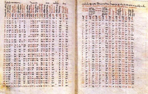
| 1514 | Johannes Werner (1468-1522) of Nuremberg proposed a method of "lunar distances". The Moon moves fairly rapidly from West to East against the background array of the fixed stars. Astronomers in or near a port city created tables based on years of careful mapping of the Moon's motion. The tables list -- for each hour of the day -- the expected separation of the Moon from a set of easily recognized bright stars. After measuring the Moon's distance from a particular star, a mariner can use the prepared tables to find out what time it is in his port city. Once that time is known, he can compare it to his local time and calculate his longitude. |
|||||||||||||||||||||||||||||
| 1530 |  |
Gemma Frisius (1508-1555) of Antwerp proposed using a portable mechanical clock that could be set to a port city's local time before setting out to sea. So long as the clock could be relied upon to keep accurate time, a mariner would only have to measure his local time in order to determine his longitude. |
||||||||||||||||||||||||||||
| 1550 | Why do we put up with these pilots, with their bad language and barbarous manners; they know neither sun, moon nor stars, nor their courses, movements or declinations; or how they rise, how they set and to what part of the horizon they are inclined; neither latitude nor longitude of the places on the globe, nor astrolabes, quadrants, cross staffs or watches, nor years of common or bissextile, equinoxes or solstices?" |
|||||||||||||||||||||||||||||
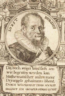
| 1585 | Jost Bürgi (1552-1632), Swiss clockmaker (below, left), develops a more accurate clock | |||||||||||||||||||||||||||||
 |
 |
|||||||||||||||||||||||||||||
| 1598 | Philip III of Spain offered a large monetary prize to the individual who solved the longitude problem -- a perpetual pension of 6,000 ducats, a life annuity of 2,000 ducats, and a cash prize of 1,000 ducats. | |||||||||||||||||||||||||||||
| 1610 | Galileo (1564-1642) discovered 4 moons of Jupiter | |||||||||||||||||||||||||||||
| 1636 | Galileo proposed using a mechanical clock and the moons of Jupiter to determine longitude. | |||||||||||||||||||||||||||||
| 1657 | Christiaan Huygens (1629-1695), Dutch astronomer, physicist, mathematician created the first working pendulum clock. | |||||||||||||||||||||||||||||
| 1658 | Kenelm Digby (1603-1665) described the "Powder of Sympathy" method of producing action at a distance which suggests a novel method of telling time at sea. | |||||||||||||||||||||||||||||
| 1660 | Huygens began working on improved pendulum clock for use at sea. | |||||||||||||||||||||||||||||
| 1667 | Paris Observatory founded. | |||||||||||||||||||||||||||||
1668 |
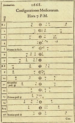 |
A chart showing pictures of the predicted positions of Jupiter's satellites at 7 p.m. on each day in January 1668. Mariners could estimate their local time at sea by observing Jupiter with a telescope and then comparing the arrangement of Jupiter's moons they saw with those depicted on the chart. | ||||||||||||||||||||||||||||
| 1675 | John Flamsteed (1646-1719) was appointed the first Astronomer Royal by King Charles II. He was the first (and for a long time, the only) scientist paid an annual salary for service to the English crown.
|
|||||||||||||||||||||||||||||
| 1676 | Flamsteed took up residence at Greenwich Observatory, located near London atop a high hill bordering the Thames River. The building was designed by Christopher Wren for the Astronomer Royal's use. Although Flamsteed was given a building from which to observe, no provision was made for the purchase observing instruments! Flamsteed purchased or commissioned the construction of many instruments at his own expense. | |||||||||||||||||||||||||||||
1707 |
Loss of Admiral Clowdisley Shovell's fleet off the coast of the Scilly Isles -- 1,647 perished. | |||||||||||||||||||||||||||||
1714 |
Queen Anne (1665-1714) of Great Britain and Ireland established a longitude prize -- £20,000!! | |||||||||||||||||||||||||||||
|